

One thing I have always been disappointed in with the public school system here in the United States is that world geography tends to fall to the back burner in the course of education. Schools often teach State geography for the state the child is located as well as the states of our own country, but when it comes to world geography, very few students who graduate from high school can locate countries like Germany and Ireland, much less all 195 countries that are recognized today. When searching for a geography course for the kids, I was really disappointed that most curriculum covers more of what would be considered biomes like deserts and swamps or geographical features such as what are mountains, rivers, and lakes but very few curriculum out there focus on teaching students to identify foreign countries on the map. This was something that was very important to me to teach my children and was extremely excited when we were given the opportunity to review the full first-year world geography curriculum from Let's Go Geography.

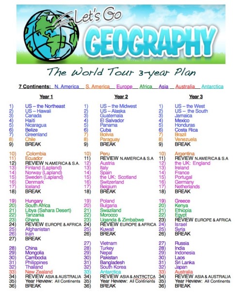
Let's Go Geography is world geography course for grades K-4th (although, in my honest opinion, older students can benefit from it as well). Lessons are written by Carol E. Henderson, a mother to five now-grown high school students who currently works as a geography teacher. Providing a tour of the world, the course breaks down into three full years of 36 weeks each (with four weeks of breaks built in each year) to cover 79 countries on all seven continents, with 6 weeks focused on regions of the United States (two regions per year). Years are broken down into two semesters.Purchasing options are available for both the full year subscription or per semester to help a variety of budget options (and coupons are available for discounts).

Each lesson takes about an hour to complete and includes five chapters for each country. A sixth chapter includes printables needed for the lessons. Each chapter includes various activities and crafts that help introduce the student to the geography and culture of the country.

Chapter 2: The Flag - Students learn to identify the countries national flag and learn about what symbolism of the country is represented.
Chapter 3: The Music - Students are given the opportunity to listen to each country's national anthem and are provided the lyrics.
Chapter 4: Let's Explore - Historic landmarks, tourist attractions, culture and people from the area are all explored through videos, photography, and facts. Additional supplemental reading material is also listed in this section.
Chapter 5: Create! - This section provides hands-on craft activities with step by step instructions.
Chapter 6: Printables - This final section provides additional printables such as notebooking pages, coloring pages and printouts of the flags suitable for a larger classroom setting.
Using Let's Go Geography
This curriculum is simple to use as everything is already thought out and planned in an easy to follow

For our schedule, we split these lessons over the course of 5 days, doing one section per school day.
Map work is always a favorite in our house. For some reason, the kids really like maps. Let's Go Geography includes plenty of map work if your kid is a map fiend like my own are. Each country lesson typically includes two maps to work with - one of the continent that the country is located so that the student can see the country in relation to the region of the world it is located and a second map that is more specific to the country that shows the capital city and other larger cities.


Fridays also meant it was Create! day, which had included some pretty neat little crafts that tie in with the lessons they have learned through the week. For example, for our first lesson about the Northeast Region of the United States, we talked about Maine and the many lighthouses that can be found along their rocky coastline. To tie into this, we made a really quick lighthouse using a red solo cup, a battery-powered tealight and a water bottle.


 I was really impressed with the choices that were selected for the videos that accompany the lessons. For example, the video for the Star Spangled Banner is of the Combined Military Academy choirs, one of the videos for Canada features native people from Nunavut, and the video for the Haiti national anthem shows school-aged children singing their national anthem in French (with English translations for the subtitles). I would have preferred to have the video links to route to Safeyoutube or a similar site rather than to Youtube as while the videos themselves were perfectly appropriate for all ages, many of the comments on the videos were not.
Overall, I've been really impressed with this curriculum and it has fulfilled my search for finding a grade-appropriate world geography program that actually teaches the countries of the world. Currently, only Year 1 is available but Year 2 and Year 3 will be available in the future. A recent study showed that 11 percent of young citizens in the US couldn't locate the US on the map, 29 percent could not locate the Pacific Ocean, 58 percent failed to locate Japan, 65 percent could not find France and 69 percent could not find the United Kingdom. I personally do not wish for my kids to be part of those statistics, that's why I'm very glad to have a quality program like this available to teach the kids where those countries are located, plus many, many more.

To learn more about Let's Go Geography, please visit their website. You can also find them on the following social media platforms:
- Facebook: https://business.facebook.com/letsgogeography
- Pinterest: https://www.pinterest.ie/letsgogeography/


No comments:
Post a Comment
Note: Only a member of this blog may post a comment.